Monday, September 3, 2012
NWS Confirms Tornado In Marion County
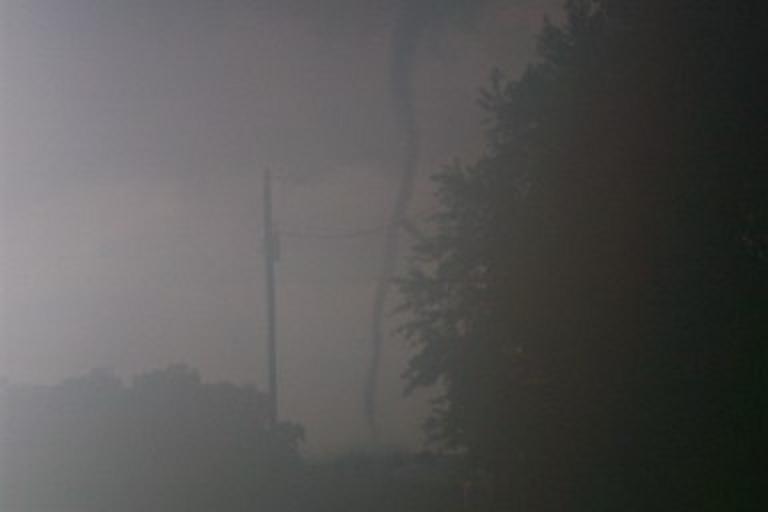
NWS Indianapolis has confirmed a brief tornado touched down on Saturday evening in Indianapolis, just northwest of downtown. This tornado occurred in association with the remnants of Hurricane Isaac. The tornado was captured on a tower camera with the touchdown occurring near 16th Street and the White River. No damage has been reported or observed, but it is likely that this tornado will be rated EF0, and the yearly statistics on the right reflect this assumption.
Monday, August 6, 2012
NWS Confirms Tornado In LaPorte County
The NWS in North Webster has confirmed an EF1 tornado struck LaPorte county on August 4. This is the first confirmed tornado in the state in just over 3 months. The survey is posted below.
PUBLIC INFORMATION STATEMENT
NATIONAL WEATHER SERVICE NORTHERN INDIANA
457 PM EDT MON AUG 6 2012 /357 PM CDT MON AUG 6 2012/
..EF1 TORNADO CONFIRMED IN NORTHEASTERN LAPORTE COUNTY INDIANA
A QLCS MOVING ACROSS NORTHERN INDIANA SPAWNED AN EF1 TORNADO NEAR
ROLLING PRAIRIE ON SATURDAY AUGUST 4TH 2012. THE TORNADO FIRST
TOUCHED DOWN AT APPROXIMATELY 520 PM CDT NEAR THE INTERSECTION OF
SR 2 AND 400E WHERE A FEW TREES FELL ONTO POWER POLES. A FEW
ADDITIONAL TREES WERE BLOWN DOWN AT THE INTERSECTION OF SR2 AND
450E. A SOUTHEAST-FACING GARAGE DOOR FAILED WHICH ALLOWED WINDS TO
PENETRATE AND BLOW OUT THE NORTHEAST WALL OF THE GARAGE ALONG THE
4600 BLOCK OF OAK KNOLL ROAD. THE TORNADO ALSO ROLLED AND DESTROYED
AN UNANCHORED SHED ON THAT PROPERTY. A BARN WAS DESTROYED NORTHEAST
OF THAT RESIDENCE BEFORE THE TORNADO LIFTED SHORTLY THEREAFTER AT
APPROXIMATELY 522PM CDT.
PATH LENGTH: APPROXIMATELY 1 MILE
PATH WIDTH: 20 YARDS
RATING: EF1
THIS SURVEY DATA IS PRELIMINARY AS THE DAMAGE INVESTIGATION
CONTINUES.
Saturday, June 30, 2012
Fifth Tornado Confirmed From March 2 Outbreak
A fifth tornado has been confirmed as part of the March 2 outbreak. It was an EF0 that struck near Darmstadt in Vanderburgh county. The tornado had a path length of approximately 2 miles and resulted in no deaths or injuries.
Monday, June 11, 2012
June 11, 1998 Tornado Outbreak
On this date in 1998, ten tornadoes struck northern and central parts of the state. The strongest tornado touched down in far eastern Marion county in the early evening and quickly intensified to F4 as it passed into Hancock county. Fortunately, this tornado resulted in no fatalities and only 4 injuries. Another strong tornado touched down in Howard county, doing significant damage in Greentown. In all, 17 people were injured in this outbreak.


Monday, June 4, 2012
Spring Tornado Lull - Is The Season Over?
After a quick start to tornado season, we have hit a relative lull. There were no tornadoes confirmed in April and 4 at the beginning of May. This begs the question: will there be any more tornadoes this year?
I reviewed our tornado records for all years from 1950-2011, and it turns out that 62/62 years (that would be 100%) have produced tornadoes after the month of May. Some of those years produced several tornado days after May. While it has been rather quiet lately, if history is any guide, there is more to come.
I reviewed our tornado records for all years from 1950-2011, and it turns out that 62/62 years (that would be 100%) have produced tornadoes after the month of May. Some of those years produced several tornado days after May. While it has been rather quiet lately, if history is any guide, there is more to come.
Friday, May 25, 2012
May 25, 2011 Tornado Outbreak - One Year Later
Today is one year since the May 25, 2011 tornado outbreak. This outbreak is a notable one in state history. In terms of tornado count, it is our second largest May tornado outbreak on record, only trailing the May 30, 2004 event (23 tornadoes). Below is a map of tornado tracks.

Monday, May 21, 2012
May 21, 1949 Killer Tornadoes
As part of a large tornado outbreak sequence across the U.S., three significant tornadoes struck portions of central Indiana on May 21, 1949. A short summary of each tornado is provided below.
Tornado #1 initially touched down southwest of Palestine, Illinois, and moved northeast through that town. All four deaths and most of the damage (peaking at F4 intensity) occurred in Illinois before the tornado moved into Sullivan county.
Tornado #2 touched down south of Cox Field on the east side of Terre Haute. The tornado damaged several houses on a NNE trek from Terre Haute to southwest of Burnett. Three deaths occurred and about ten people were injured.
Tornado #3 proved to be the worst tornado of the group. This tornado touched down near Graysville and moved through Shelburn, devastating part of that town. The tornado continued northeast, passing south of Bowling Green and ending north of Jordan in Owen county. Farms were destroyed at several points along the path. The worst damage occurred in the northwest part of Shelburn, where many homes were damaged/destroyed and thirteen people died. In all, this F4 tornado killed fourteen people on a path that may have exceeded 40 miles. Hundreds of animals were also killed.
Source:
Thomas P. Grazulis, Significant Tornadoes 1680-1991 (Environmental Films, 1993).
Wednesday, May 16, 2012

Monday, May 14, 2012
May 14, 1972 Indianapolis Area Tornado
Today marks the 40th anniversary of one of the most powerful tornadoes to strike the Indianapolis area since records began. The tornado had a non-continuous damage path of 29 miles and first touched down on the east side of Indianapolis in the 9700 block of East Washington Street. The tornado was seen by a number of people and pictures were taken showing another funnel cloud. At the Drake Terrace Apartments, a second floor wall was blown down. In the 1100 block of North German Church Road, three steel high tension towers were blown down. Some of the worst damage occurred in the Heather Hills subdivision where ten houses were flattened. In Marion county, about 70 homes were damaged or destroyed. In Mount Comfort, clocks were stopped at 12:25 PM and a railroad car was tipped over. Near Eden, roofs were damaged and trees were uprooted. Northwest of Markleville, several mobile homes were severely damaged. The last damage occurred at Mechanicsburg where a barn was unroofed. Somewhat miraculously, nobody was killed but about 20 people were injured.
Several F3 tornadoes have struck Indianapolis since records began, but the 1972 tornado may be the only F4 that has occurred within the Indianapolis city limits. Another tornado in 1998 began in eastern Marion county but apparently did not produce F4 damage until it reached Hancock county.
Sources:
Storm Data
Thomas P. Grazulis, Significant Tornadoes 1680-1991 (Environmental Films, 1993).
Monday, May 7, 2012
A Look At Tornado Emergencies
In any given year, dozens of tornado warnings are likely to be issued in Indiana. Some of these result in confirmed tornadoes while others do not. A rare type of tornado warning - a tornado emergency - is reserved for high-end events where a particularly dangerous tornado is known to be on the ground.
Since 2002, there have been 3 tornado emergency days here - 9/20/2002, 10/18/2007 and 3/2/2012. In many cases, only follow-up statements and not the original tornado warning contained the emergency wording. Warnings/statements containing the emergency wording and counties affected are listed below.
TOR = original tornado warning
SVS# = follow-up statement number
9/20/2002:
Northern Johnson/Marion counties: TOR (no SVS statements available)
Hancock county: TOR (no SVS statements available)
10/18/2007:
Southern Elkhart county: SVS1, SVS2, SVS3
3/2/2012:
Northwestern Clark county: SVS3
Northern Clark/southern Scott/Jefferson counties: SVS1, SVS2, SVS3
Northern Clark county: SVS1
Southern Ripley/southwestern Dearborn/Ohio/Switzerland counties: SVS1, SVS2
Switzerland county: SVS1
Friday, May 4, 2012
NWS Confirms Tornado In Clay County
The NWS in Indianapolis has confirmed another tornado, an EF0 near Cory in Clay county. The tornado touched down briefly in a field and was about 50 yards wide.
The event total now stands at 4.
The event total now stands at 4.
Thursday, May 3, 2012
NWS Confirms Tornado In Fountain County
The NWS in Indianapolis has confirmed an additional tornado from May 1, a brief EF0 near Yeddo in Fountain county. This tornado was on the ground for about one tenth of a mile and was 50 yards wide. Little if any damage occurred.
Wednesday, May 2, 2012
NWS Confirms Tornado In Franklin County
The National Weather Service in Wilmington, Ohio has confirmed a tornado from Tuesday's storm in Franklin county.
PUBLIC INFORMATION STATEMENT
NATIONAL WEATHER SERVICE WILMINGTON OH
533 PM EDT WED MAY 2 2012
...TORNADO CONFIRMED NEAR 1/2 MILE ESE MT. CARMEL IN FRANKLIN COUNTY
INDIANA...
LOCATION...1/2 MILE ESE MT. CARMEL IN FRANKLIN COUNTY INDIANA
DATE...MAY 1 2012
ESTIMATED TIME...520 PM EDT
MAXIMUM EF-SCALE RATING...EF1
ESTIMATED MAXIMUM WIND SPEED...95 MPH
MAXIMUM PATH WIDTH...100 YARDS
PATH LENGTH...1.3 MILES
BEGINNING LAT/LON...39.41N / -84.86
ENDING LAT/LON...39.40N / -84.84
* FATALITIES...0
* INJURIES...0
* THE INFORMATION IN THIS STATEMENT IS PRELIMINARY AND SUBJECT TO
CHANGE PENDING FINAL REVIEW OF THE EVENT(S) AND PUBLICATION IN NWS
STORM DATA.
..SUMMARY
THE NATIONAL WEATHER SERVICE IN WILMINGTON OH HAS CONFIRMED A
TORNADO NEAR 1/2 MILE ESE MT. CARMEL IN FRANKLIN COUNTY INDIANA ON
MAY 1 2012.
SIGNIFICANT DAMAGE OCCURRED TO 3 FARMSTEADS ALONG THE PATH OF THE
TORNADO. THERE WAS DAMAGE TO SEVERAL LARGE BUILDINGS WHICH
CONSISTED PRIMARILY OF ALUMINUM AND WOOD. SEVERAL SMALL SHEDS
WHICH WERE NOT ANCHORED DOWN WERE EITHER BLOWN COMPLETELY OFF
THEIR FOUNDATION OR MOVED FROM THE FOUNDATION. SOME OF THE LARGER BUILDINGS
HAD COLLAPSED WALLS...DOORS BLOWN IN...BROKEN WINDOWS AND LARGE SECTIONS
OF THEIR ROOFS TORN OFF. SEVERAL SILOS WERE SEVERELY DAMAGED.
A NARROW PATH OF WOOD AND METAL DEBRIS EXTENDED ACROSS THE FARM
FIELDS BETWEEN THE FARMSTEADS. EARLY IN THE PATH OF THE TORNADO
YOU COULD SEE METAL DEBRIS WRAPPED AROUND THE BASE OF A HIGH
TENSION WIRE TOWER. SEVERAL TREES 3 TO 6 INCHES IN DIAMETER WERE
SNAPPED AND TWISTED.
NWS Confirms Tornado In Montgomery County
The NWS in Indianapolis has confirmed that an EF1 tornado struck Montgomery county yesterday evening. Details are below.
At least one tornado has been confirmed as part of the severe weather that produced flooding rains, hail to golf ball size and areas of wind damage Tuesday afternoon and evening. The tornado touched down southeast of Crawfordsville near New Ross along County Road 500S between CR625E and CR700E. From eyewitness Skywarn storm spotters' reports, pictures and videos of the tornado and damage, and from Indianapolis TV stations' damage pictures, the tornado is being rated preliminarily as an EF1 with winds estimated between 100 mph and 110 mph. The tornado began at approximately 736 pm, was on the ground for about a half mile, and lifted around 737 pm. The damage rating was based on a destroyed barn, and damaged nearby homes, trees and power poles.
At least one tornado has been confirmed as part of the severe weather that produced flooding rains, hail to golf ball size and areas of wind damage Tuesday afternoon and evening. The tornado touched down southeast of Crawfordsville near New Ross along County Road 500S between CR625E and CR700E. From eyewitness Skywarn storm spotters' reports, pictures and videos of the tornado and damage, and from Indianapolis TV stations' damage pictures, the tornado is being rated preliminarily as an EF1 with winds estimated between 100 mph and 110 mph. The tornado began at approximately 736 pm, was on the ground for about a half mile, and lifted around 737 pm. The damage rating was based on a destroyed barn, and damaged nearby homes, trees and power poles.
Tuesday, May 1, 2012
Tornadoes Reported In Several Counties Today
Several reports of tornadoes have come in today. As of this writing, tornadoes have been reported in Bartholomew, Fountain and Montgomery counties. There was also significant wind damage (possible tornado) in Franklin county. Storm surveys are scheduled for tomorrow and they will be posted as they come in.
Monday, April 30, 2012
Lack Of April Tornadoes This Year
April is winding down and so far there have been no reports of tornadoes in the state. If this holds up, it would break our string of 3 consecutive months with tornadoes and leave 2012 tied with 1976 as the only years on record with tornadoes in January, February and March.
Friday, April 27, 2012
Historic April 25-28, 2011 Tornado Outbreak
Who can forget the unbelievable tornado outbreak of April 25-28, 2011, which produced hundreds of tornadoes, took hundreds of lives and devastated many communities in southern and eastern states? Indiana shares a small part of this massive outbreak with 3 confirmed tornadoes - two on the 26th and one on the 27th.
To read the storm surveys for these 3 tornadoes, click here
To read the storm surveys for these 3 tornadoes, click here
Wednesday, April 25, 2012
April 25, 1961 Tornado
On April 25, 1961, at least one powerful F4 tornado swept across portions of east central Indiana. Touching down in Shelby county a few miles north of Shelbyville, this tornado passed over I-74 with eyewitnesses reporting multiple vorticies. The tornado destroyed barns and homes in Shelby and Rush counties. Additional heavy damage occurred near the town of Boston where homes were destroyed. The tornado eventually passed into Ohio. Several people were injured but fortunately there were no fatalities.
This event may have actually been two separate tornadoes but it is not clear.
Source:
Thomas P. Grazulis, Significant Tornadoes 1680-1991 (Environmental Films, 1993).
This event may have actually been two separate tornadoes but it is not clear.
Source:
Thomas P. Grazulis, Significant Tornadoes 1680-1991 (Environmental Films, 1993).
Tuesday, April 24, 2012
A Closer Look At Significant Tornado Days, 1875-2011
In the previous post, I posted a monthly breakdown of significant tornadoes and tornado days from 1875-2011. Now I will take a closer look at significant tornado days during the same time period, including our most prolific outbreaks.
As mentioned before, a significant tornado is defined as any tornado of at least F2/EF2 strength. A significant tornado day need only have one tornado of that intensity, but as we will see, not all significant tornado days are equal. In our history, significant tornado days have produced anywhere from 1 to 20 significant tornadoes.
Using Grazulis data for 1875-1949 and NOAA data for 1950-2011, there have been a total of 602 F2/EF2+ tornadoes on 332 days. 226 of 332 days produced only one significant tornado and 46 days produced only two significant tornadoes, which means that 272 of 332 days produced just one or two significant tornadoes. Recurrence rates for various numbers of significant tornadoes are below.
332 days with at least 1 significant tornado..........1 day per 0.4 years or 2.4 days per year
106 days with at least 2 significant tornadoes.......1 day every 1.3 years
60 days with at least 3 significant tornadoes.........1 day every 2.3 years
34 days with at least 4 significant tornadoes.........1 day every 4.0 years
20 days with at least 5 significant tornadoes.........1 day every 6.9 years
16 days with at least 6 significant tornadoes.........1 day every 8.6 years
7 days with at least 7 significant tornadoes...........1 day every 19.6 years
Looking at the recent era from 1980-2011, there have been 139 F2/EF2+ tornadoes on 68 days per NOAA records. 43 of 68 days produced only one significant tornado and 15 days produced only two significant tornadoes, which means that 58 of 68 days produced just one or two significant tornadoes. Recurrence rates for various numbers of significant tornadoes are below.
68 days with at least 1 significant tornado..........1 day per 0.5 years or 2.1 days per year
25 days with at least 2 significant tornadoes.......1 day every 1.3 years
10 days with at least 3 significant tornadoes.......1 day every 3.2 years
10 days with at least 4 significant tornadoes.......1 day every 3.2 years
5 days with at least 5 significant tornadoes.........1 day every 6.4 years
4 days with at least 6 significant tornadoes.........1 day every 8.0 years
3 days with at least 7 significant tornadoes.........1 day every 10.7 years
Using Grazulis ratings for 1875-1949 and NOAA for 1950-2011, here are the top 20 significant tornado days and the number of significant tornadoes they produced. A list of all days with 2 or more F2/EF2+ tornadoes is below that.
June 2, 1990: 20
April 3, 1974: 17
April 11, 1965: 10
November 22, 1992: 10
March 23, 1917: 7
March 28, 1920: 7
March 10, 1986: 7
June 14, 1880: 6
May 12, 1886: 6
April 17, 1922: 6
March 6, 1956: 6
April 3, 1956: 6
November 26, 1965: 6
October 24 1967: 6
March 12, 1976: 6
May 25, 2011: 6
February 25, 1956: 5
March 6, 1961: 5
April 30, 1962: 5
May 30, 2004: 5

Significant Tornadoes/Tornado Days By Month, 1875-2011
Significant tornadoes represent a greater threat to life and property compared to weak tornadoes, which means that they deserve more attention. What defines a "significant" tornado? Some define a significant tornado to be any tornado that causes fatalities or one of at least F2/EF2 strength. There is no right or wrong answer but the latter criteria will be used for the purpose of this post.
When examining Indiana's tornado record, it is clear that there is a long history of significant tornadoes. Some years/decades have been more active than others to be sure, which may be due to cyclical weather patterns or just plain luck (a tornado must hit something to even have a chance to be rated EF2, after all).
In most instances on this blog, I use Grazulis ratings for tornadoes prior to 1950 and NOAA ratings for tornadoes since 1950. I have done that again here, but this time will also utilize the Grazulis database up to 1991 to demonstrate the differences.
Combining Grazulis data from 1875-1949 and NOAA data for 1950-2011, there were a total of 602 significant tornadoes and 332 significant tornado days.
The March to June period contributes a majority of the significant tornadoes and tornado days, but other months certainly should not be overlooked. November, for example, has produced a respectable number of significant tornadoes despite the low number of significant tornado days.
When using Grazulis data from 1875-1991 and NOAA data for 1992-2011, there were a total of 505 significant tornadoes and 282 significant tornado days. This is a substantial drop compared to above (97 fewer tornadoes and 50 fewer tornado days), but this trend is not unique to Indiana. The Fujita scale was not invented until the early 1970's, which means that tornadoes that occurred prior to that were rated retroactively, often by inexperienced individuals. There is not a large difference in the degree of damage between a high end EF1 and a low end EF2 tornado, and ratings (NOAA) were particularly liberal in the 1950's-1970's as the Fujita scale was just in its infancy.
Although the totals vary depending on the database, the March to June period is still the most active.
There are probably countless ways to analyze 137 years of data and this just a quick look. I will have another post later.
When examining Indiana's tornado record, it is clear that there is a long history of significant tornadoes. Some years/decades have been more active than others to be sure, which may be due to cyclical weather patterns or just plain luck (a tornado must hit something to even have a chance to be rated EF2, after all).
In most instances on this blog, I use Grazulis ratings for tornadoes prior to 1950 and NOAA ratings for tornadoes since 1950. I have done that again here, but this time will also utilize the Grazulis database up to 1991 to demonstrate the differences.
Combining Grazulis data from 1875-1949 and NOAA data for 1950-2011, there were a total of 602 significant tornadoes and 332 significant tornado days.
 |
| Click For Larger Image
|
When using Grazulis data from 1875-1991 and NOAA data for 1992-2011, there were a total of 505 significant tornadoes and 282 significant tornado days. This is a substantial drop compared to above (97 fewer tornadoes and 50 fewer tornado days), but this trend is not unique to Indiana. The Fujita scale was not invented until the early 1970's, which means that tornadoes that occurred prior to that were rated retroactively, often by inexperienced individuals. There is not a large difference in the degree of damage between a high end EF1 and a low end EF2 tornado, and ratings (NOAA) were particularly liberal in the 1950's-1970's as the Fujita scale was just in its infancy.
 |
| Click For Larger Image
|
There are probably countless ways to analyze 137 years of data and this just a quick look. I will have another post later.
Friday, April 20, 2012
April 20, 2004 "Surprise" Tornado Outbreak
Today is the eight year anniversary of the April 20, 2004 tornado outbreak. It is hard to believe it has been that long. Simply put, it remains one of the most poorly forecasted severe weather events I have ever seen. Thankfully no lives were lost in Indiana but that was not the case in other areas. You can view an excellent writeup on this event here
Also, be sure to check out the photo gallery, which contains several pictures from this event.
Also, be sure to check out the photo gallery, which contains several pictures from this event.
 |
| Map of Tornado Tracks |
Thursday, April 19, 2012
Remembering A Pair Of Significant April 19 Outbreaks
April 19, 1996 - 13 tornadoes
April 19, 2011 - 29 tornadoes
 |
| Map of Tornado Tracks |
April 19, 2011 - 29 tornadoes
 |
| Map of Tornado Tracks |
Wednesday, April 18, 2012

Tuesday, April 17, 2012
Tornado Photo Gallery - 2006 To Present
Here are some tornado pictures from 2006 to present. More pictures will be added here (and possibly the older photo sections) in the future so be sure to check back from time to time.
Click each image for larger version.


Click each image for larger version.

June 25, 2006 - Odell. Photo by Tanya Snoeberger

June 25, 2006 - Odell. Photo by Kerri Wagner

April 11, 2007 - near Arcadia. Photo by David Gorman

April 11, 2007 - near Lizton. Photo by Rebecca Saylor

June 3, 2008 - Edinburgh. Photo by Gary Stofer and David Eaton

June 4, 2010 - near Wolcott. Photo by Ray Allie

May 22, 2011 - near Rensselaer. Photo by Joann Skinner

May 25, 2011 - near Bedford. Photo by Stacey Cummings

May 25, 2011 - near Bedford. Photo by Stacey Cummings

May 25, 2011 - near Bedford. Photo by Stacey Cummings

March 2, 2012 - near Borden. Photo by Larry Williams

March 2, 2012 - Henryville. Photo by Evan Bentley

March 2, 2012 - Henryville. Photo by Skip Talbot
Monday, April 16, 2012
Tornado Photo Gallery - 1990 To 2005
This post covers the years from 1990 through 2005. The final part (2006-present) will be up tomorrow.
Click each image for larger version.


Click each image for larger version.

June 2, 1990 - Loogootee. Photo by Tony Dant

October 24, 2001 - near North Webster. Photo by Ed Sloan

April 20, 2004 - Jamestown. Photo by Greg Gochenour

April 20, 2004 - Jamestown. Photo by Andrew McLendon

April 20, 2004 - Jamestown. Photo by Andrew McLendon

April 20, 2004 - Lincolnville. Photo by Russ Kennedy

May 30, 2004 - Indianapolis. Photo by Chris and Becky Kuhlman

May 30, 2004 - northeast of Mooresville. Photo by Chris and Becky Kuhlman

May 30, 2004 - northeast of Mooresville. Photo by Chris and Becky Kuhlman

May 30, 2004 - near Little Point. Photo by Eric Wasson

May 30, 2004 - west of Monrovia. Photo by Brett and Rebecca Everett

May 30, 2004 - west of Monrovia. Photo by Brett and Rebecca Everett
May 30, 2004 - west of Monrovia. Photo by Brett and Rebecca Everett

November 6, 2005 - Evansville. Photo by Deaconess Women's Hospital
Sunday, April 15, 2012
Tornado Photo Gallery - Pre 1990 Tornadoes
This is part 1 of a collection of tornado photographs that I have gathered. All pictures are of tornadoes prior to 1990. Many of these pictures were taken from various NWS websites.
Part 2 of the collection (1990-2005) will be posted soon.
Click each image for larger version.


Part 2 of the collection (1990-2005) will be posted soon.
Click each image for larger version.

April 11, 1965 - near Goshen. Photo by Paul Huffman

April 11, 1965 - near Kokomo. Photo by Kokomo Morning Times

April 3, 1974 - Hanover. Photo by Paul Blume

April 3, 1974 - Hanover. Photo by Paul Blume

April 3, 1974 - Hanover. Photo by Rosie Graves

April 3, 1974 - Hanover. Photo by Rosie Graves

April 3, 1974 - Hanover. Photo by Rosie Graves

April 3, 1974 - Hanover. Photo by Rosie Graves

April 3, 1974 - Hanover. Photo by Rosie Graves

April 3, 1974 - Parker City. Photo by Mick

April 3, 1974 - Parker City. Photo by Mick
Wednesday, April 11, 2012
April 11, 1965 Palm Sunday Tornado Outbreak
Today marks the anniversary of the 1965 Palm Sunday tornado outbreak - not only one of the worst tornado events in U.S. history but also Indiana history. In Indiana, 137 people were killed and nearly 2000 were injured as a series of violent tornadoes impacted the northern and central part of the state.
Although tornado records are more limited farther back in time, there are some data available for Indiana tornadoes going back approximately 200 years. During that time, few events have even come close to competing with the 1965 outbreak in terms of fatalities, number of killer tornadoes and number of violent tornadoes. The deadliest tornado outbreaks in Indiana history are as follows:
1. April 11, 1965: 137
2. March 18, 1925: 75 (actual number may be slightly higher)
3. April 3, 1974: 47
# of killer tornadoes:
1. April 3, 1974: 8
2. April 11, 1965: 7
3. June 30, 1877; June 14, 1880; April 17, 1922: 4
# of violent tornadoes (F4 or greater):
1. April 3, 1974: 9
2. April 11, 1965: 8
3. June 2, 1990: 5
To put the April 11, 1965 Indiana death toll in perspective, more people were killed in less than 4 hours than in the entire 40 year period prior to that. The outbreak is also responsible for slightly more than half of our tornado deaths from 1950-2012.
In all, ten tornadoes were confirmed in Indiana. The first tornado touched down around 5:45 PM in Starke county. It moved from 3 miles southwest of Hamlet, passed across Koontz Lake and ended about 5 miles south of Elkhart. Numerous homes and cottages were destroyed.
The second tornado touched down in St. Joseph county about 5 miles southwest of Wakarusa. The tornado developed a double funnel structure as it crossed US 33 between Elkhart and Goshen. Numerous deaths occurred at the Midway Trailer Court as many trailers were destroyed. Additional deaths occurred in the Middlebury area as homes were leveled and swept away. Elkhart Truth reporter Paul Huffman took a series of photographs, unknowingly capturing what would become the iconic image of this outbreak (the double funnel) and perhaps one of the most spectacular tornado photographs ever taken. Huffman was standing in the shoulder of US 33 when the famous picture was shot.
 |
| Click For Larger Image |
The third tornado affected Porter and La Porte counties, moving from Morgan Township to just beyond South Center. Homes were heavily damaged southwest of Wanatah. Other homes and barns were destroyed south of Kingsford Heights.
The fourth tornado touched down southeast of Goshen in Elkhart county and ended near Brighton. Most of the deaths occurred in the Rainbow Lake and Shore areas, where intensity was near F5.
The fifth tornado touched down in northwest Steuben county before moving into Michigan. All of the deaths and most of the damage occurred in Michigan.
The sixth tornado, the first of the day to impact central Indiana, occurred in Tippecanoe and Clinton counties. This tornado is often listed as touching down southeast of Lafayette but tornado damage may have started as far west as Odell. A few homes were leveled at Mulberry and Moran with the worst damage occurring in Clinton county.
The seventh tornado touched down south of South Bend, passing through parts of St. Joseph, Elkhart and LaGrange counties. Many people were killed at Dunlap as the Sunnyside and Kingston Heights housing developments were devastated.
The eighth tornado touched down in Montgomery county southeast of Crawfordsville. This tornado affected parts of three counties - Montgomery, Boone and Hamilton. The funnel cut a mile wide swath north of Lebanon, destroying dozens of homes and killing several people. Additional deaths occurred around Sheridan before the tornado dissipated south of Arcadia.
The ninth tornado of the day touched down just southwest of Russiaville, heavily damaging much of that town. Near Alto and Kokomo, the funnel widened to about 1 mile and destroyed dozens of homes. Additional homes were leveled along the track before the tornado finally dissipated in Grant county north of Arcana.
The tenth and final tornado to impact Indiana touched down in Blackford county near the town of Roll. Heavy damage occurred in Wells county near Keystone and near Linn Grove in Adams county. The tornado then moved into Ohio.
 |
| Map of Tornado Tracks |
Tornado narratives and pre-1950 data obtained from:
Thomas P. Grazulis, Significant Tornadoes 1680-1991 (Environmental Films, 1993).
Subscribe to:
Comments (Atom)