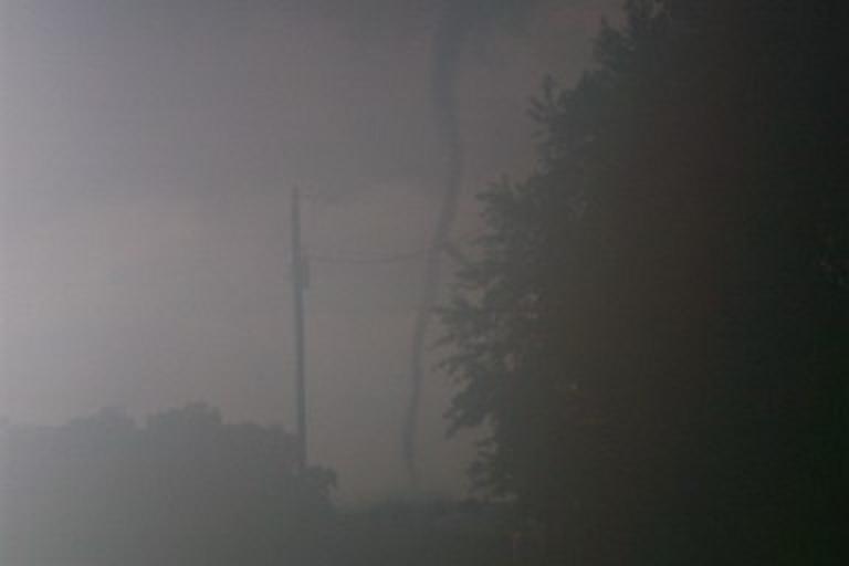
A weak tornado of EF1 intensity and winds estimated from 90 to 100
mph caused damage along an approximate two mile path in Plainfield and
Indianapolis Tuesday afternoon June 24th. The tornado touched down near
Perry Road and US40 in Plainfield at approximately 232 PM EDT. The
first significant damage occurred at a vehicle auction facility with one
building heavily damaged and over 200 cars impacted by flying debris.
Minor straight-line wind tree damage was observed west of the auction
facility near Township Line Road and Smith Road. The tornado traveled
northeast causing damage to nearly two dozen homes in Hendricks County
with the most severe damage along County Road 200S near County Road
1050E. At this location the tornado lofted a camping trailer into the
air and tossed it approximately 175 feet to the east onto a house and
also removed a substantial portion of that houses roof. This damage was
rated EF1 with winds estimated at 95 to 100 mph.
The tornado continued tracking northeast through the Bentwood
subdivision in east Hendricks County and into the Cameron Meadows
subdivision of Indianapolis. The most significant damage in Indianapolis
was along Raceway Road near Blue Pine Drive where a couple homes had
portions of their roofs removed by the tornado. This damage was rated
EF1 with winds estimated near 97 mph. The tornado lifted at
approximately 240 PM EDT in this subdivision though intermittent
straight-line wind damage to trees occurred from here to near Rockville
Road and I-465 all the way to the town of Speedway.
Indianapolis officials estimated 75 to 100 homes received at least
minor damage in Indianapolis. Also, including the automobiles damaged at
the auto auction center, more than 200 vehicles sustained varying
degrees of damage.
more here:
http://www.crh.noaa.gov/news/display_cmsstory.php?wfo=ind&storyid=103059&source=0
Showing posts with label indianapolis. Show all posts
Showing posts with label indianapolis. Show all posts
Wednesday, June 25, 2014
Monday, September 3, 2012
NWS Confirms Tornado In Marion County
NWS Indianapolis has confirmed a brief tornado touched down on Saturday evening in Indianapolis, just northwest of downtown. This tornado occurred in association with the remnants of Hurricane Isaac. The tornado was captured on a tower camera with the touchdown occurring near 16th Street and the White River. No damage has been reported or observed, but it is likely that this tornado will be rated EF0, and the yearly statistics on the right reflect this assumption.
Monday, May 14, 2012
May 14, 1972 Indianapolis Area Tornado
Today marks the 40th anniversary of one of the most powerful tornadoes to strike the Indianapolis area since records began. The tornado had a non-continuous damage path of 29 miles and first touched down on the east side of Indianapolis in the 9700 block of East Washington Street. The tornado was seen by a number of people and pictures were taken showing another funnel cloud. At the Drake Terrace Apartments, a second floor wall was blown down. In the 1100 block of North German Church Road, three steel high tension towers were blown down. Some of the worst damage occurred in the Heather Hills subdivision where ten houses were flattened. In Marion county, about 70 homes were damaged or destroyed. In Mount Comfort, clocks were stopped at 12:25 PM and a railroad car was tipped over. Near Eden, roofs were damaged and trees were uprooted. Northwest of Markleville, several mobile homes were severely damaged. The last damage occurred at Mechanicsburg where a barn was unroofed. Somewhat miraculously, nobody was killed but about 20 people were injured.
Several F3 tornadoes have struck Indianapolis since records began, but the 1972 tornado may be the only F4 that has occurred within the Indianapolis city limits. Another tornado in 1998 began in eastern Marion county but apparently did not produce F4 damage until it reached Hancock county.
Sources:
Storm Data
Thomas P. Grazulis, Significant Tornadoes 1680-1991 (Environmental Films, 1993).
Monday, April 16, 2012
Tornado Photo Gallery - 1990 To 2005
This post covers the years from 1990 through 2005. The final part (2006-present) will be up tomorrow.
Click each image for larger version.


Click each image for larger version.

June 2, 1990 - Loogootee. Photo by Tony Dant

October 24, 2001 - near North Webster. Photo by Ed Sloan

April 20, 2004 - Jamestown. Photo by Greg Gochenour

April 20, 2004 - Jamestown. Photo by Andrew McLendon

April 20, 2004 - Jamestown. Photo by Andrew McLendon

April 20, 2004 - Lincolnville. Photo by Russ Kennedy

May 30, 2004 - Indianapolis. Photo by Chris and Becky Kuhlman

May 30, 2004 - northeast of Mooresville. Photo by Chris and Becky Kuhlman

May 30, 2004 - northeast of Mooresville. Photo by Chris and Becky Kuhlman

May 30, 2004 - near Little Point. Photo by Eric Wasson

May 30, 2004 - west of Monrovia. Photo by Brett and Rebecca Everett

May 30, 2004 - west of Monrovia. Photo by Brett and Rebecca Everett
May 30, 2004 - west of Monrovia. Photo by Brett and Rebecca Everett

November 6, 2005 - Evansville. Photo by Deaconess Women's Hospital
Tuesday, September 20, 2011
September 20, 2002 Tornadoes
Today marks the 9 year anniversary of the September 20, 2002 tornado outbreak. When we think about local tornado climatology, we don't tend to think of September as being an active month. The events of September 20, 2002 - and one tornado in particular - would turn climatology on its head.
The first of 6 tornadoes touched down in Posey county at 9:40 AM local time. It was on the ground for less than a quarter mile and caused no significant damage. The same thunderstorm would produce a stronger F2 tornado near Poseyville at 9:50 AM local time. This tornado destroyed 10 mobile homes and 4 other buildings and had a path length just under 5 miles.
After a break, another tornado would form in northwestern Pike county and move into Knox and Daviess counties. In Knox county, the tornado destroyed a few homes and damaged several others and peaked at F2 intensity. A conservation officer in his vehicle was thrown an eighth of a mile by the tornado. The tornado weakened to F0 as it moved into Daviess county, finally lifting after being on the ground for over 13 miles.
After another break in the action, the most notable tornado of the day touched down in Ellettsville at 12:59 PM local time and started producing F3 damage shortly thereafter. After weakening and heading northeast into Morgan county, the tornado reintensified and produced more F3 damage in Martinsville. The tornado remained at F2-F3 strength as it continued northeast into Johnson and Marion counties, producing additional F3 damage at Greenwood. The tornado took a slight left turn and entered the city of Indianapolis around 1:45 PM, generally producing F1-F2 damage on its trek through the southern and eastern portions of the city. The tornado exited Marion county just after 2 PM and continued northeast through several more counties, producing its final damage in Hartford City at 3:20 PM. In all, about 130 people were injured by this tornado with damage in excess of $150 million.
2 other tornadoes occurred simultaneous to the long track tornado. One of them damaged 10 single family homes and 30 mobile homes in Henry county and was rated F2. The other tornado destroyed 2 barns and 2 mobile homes in Rush county and was rated F0.
This event probably would've been forgettable were it not for the long-tracked F3 tornado. This tornado is interesting in several respects:
1) Its path length of 112 miles makes it one of the longest tracked tornadoes to ever hit the state (reanalysis of the April 3, 1974 Monticello tornado reduced the path length from 121 to 108 miles). The tornado was on the ground for a total of 2 hours and 21 minutes, giving it an average forward speed of about 48 miles per hour.
2) The tornado passed through 9 counties, second most behind the April 3, 1974 Monticello tornado
3) It is the second longest tornado to hit the United States in the month of September since 1950
4) The tornado did not occur as part of a discrete supercell; rather, it formed along a QLCS/squall line
5) Although the tornado was rain-wrapped much of the time and passed through urbanized areas, no deaths occurred
Here is a map of the tornado paths courtesy of NWS Indianapolis (note: Posey county tracks not included)

Monday, September 12, 2011
September 12, 1988 Indianapolis Tornado
Still waiting for the May Storm Data to come in so the May tornado statistics can be finalized. Hopefully this occurs sometime in the next couple weeks.
Anyway, since posts have been lacking as of late, I thought I'd mention that today is the anniversary of a F1 tornado that hit Indianapolis. The tornado began on the north side of the city and moved northeast through Marion, Hamilton and Madison counties. Roofs and automobiles were reportedly damaged along the path. The tornado caused intermittent damage over a path length of about 35 miles and resulted in 1 injury.
Anyway, since posts have been lacking as of late, I thought I'd mention that today is the anniversary of a F1 tornado that hit Indianapolis. The tornado began on the north side of the city and moved northeast through Marion, Hamilton and Madison counties. Roofs and automobiles were reportedly damaged along the path. The tornado caused intermittent damage over a path length of about 35 miles and resulted in 1 injury.
Friday, August 12, 2011
Top 10 Tornadoes Since 1950
#7 - September 20, 2002 Ellettsville to Hartford City Tornado
This is probably one of the lesser known tornadoes but that doesn't mean it wasn't impressive. It was on the ground for 2 hours and 21 minutes and traveled 112 miles and charged through the south and east side of Indianapolis. Fortunately, there were no fatalities but over 100 people were injured. This tornado was rated F3 and caused over $100 million in damage.
Friday, June 17, 2011
Biggest Summer Tornado Outbreaks Since 1950
Although tornadoes can and do occur here during Summer, they do not happen as frequently and tend to be weaker than those in Spring. This is mainly due to the fact that temperature gradients are less intense during Summer and thus the jet stream tends to be weaker and farther north. This lack of stronger winds aloft is detrimental to the production of strong tornadoes, but they can still occur when conditions come together just right.
I have scanned the tornado database back to 1950 in order to establish our biggest summertime tornado outbreaks. Here are some of the biggest outbreaks between the Summer Solstice and Autumn Equinox (roughly June 21-September 22).
June 26, 1973: 10 tornadoes struck the state, 9 of which occurred in central/southern Indiana. The strongest was a F2 near Bloomington.
July 30, 1992: 6 tornadoes occurred, including an F2 in Morgan county and a F3 in Johnson county. The Johnson county tornado had a path length of about 7 miles and injured 25 people.
September 20, 2002: 6 tornadoes happened with 4 of them rated F2 or higher. The highlight of this event was the long track F3 tornado that started near Ellettsville and ended near Hartford City in Blackford county. This impressive tornado had a path length of 112 miles, injured over 100 people and caused more than $100 million damage. For more on this event, click here
June 23, 2010: 6 tornadoes occurred in northern Indiana, mostly in Elkhart county. These tornadoes were spawned from a quasi-linear convective system which moved across the area.
August 9, 1969: 5 tornadoes occurred, the most significant being an early morning F3 in Indianapolis which injured 6 people.
September 19, 1988: 5 weak tornadoes struck various parts of the state, injuring 3 people.
July 26, 2005: 5 tornadoes occurred, including a F2 in Cass and Miami counties. Nobody was injured.
June 27, 2008: 5 brief EF0 tornadoes occurred, one of which injured 2 people in Morgan county.
Special mention: On July 9, 1980, a F4 tornado struck Rush county, killing 2 people. Although there was only one other tornado on this date (a weak F0 near Crawfordsville), this event is significant because it is the only known F4 tornado to hit Indiana during the summer.
Monday, June 13, 2011
Frequency Of Tornadoes From Remnants Of Tropical Systems
Yesterday was the 6 year anniversary of Tropical Storm Arlene's passage (or at least its remnants) through Indiana. While these events can bring us heavy rain from time to time, they are usually fairly forgettable. However, Arlene is a bit of a stand out because it produced 2 tornadoes south of Indianapolis. That got me thinking - how often do tropical remnants produce tornadoes here?
In an attempt to answer that question, I scanned the National Hurricane Center's records since 1950 (since that is about the time that tornado record keeping began to improve). It was assumed that a remnant tropical system would've at least needed to reach the latitude of Kentucky to have a substantial chance of producing a tornado in Indiana. I found 23 such systems which I am not going to list here. I then chose to narrow the criteria to systems in which the remnant circulation passed through Illinois or Indiana, thus achieving greater latitude and putting us along or east of the track. I found 14 of those systems and they are listed below:
1960 Tropical Storm #1
1961 Hurricane Carla
1965 Hurricane Betsy
1968 Tropical Storm Cindy
1979 Hurricane Bob
1979 Tropical Storm Claudette
1988 Hurricane Gilbert
1995 Hurricane Erin
2005 Tropical Storm Arlene
2005 Hurricane Dennis
2005 Hurricane Katrina
2005 Hurricane Rita
2008 Hurricane Gustav
2008 Hurricane Ike
In order to determine whether these tropical events produced any tornadoes in our area, I examined tornado records to coincide with the general timeframe that the remnant circulation passed through the area. In a few cases, tornadoes occurred 1 or 2 days after the remnants passed and it was determined that those tornadoes were caused by a different weather system. Out of the 14 storms listed above, I can only find 2 storms which were undoubtedly directly responsible for tornado production in the state - Tropical Storm Arlene in 2005 and Hurricane Gustav in 2008. As previously stated, the remnants of Arlene produced 2 tornadoes, while the remnants of Gustav generated a tornado in Jasper county.
A potential third tornado case is Hurricane Gilbert in 1988. The remnants of Gilbert moved northeastward through Missouri and Illinois, apparently in association with a significant trough/low pressure system in the Midwest. 5 tornadoes occurred in central and southern Indiana, but it is unclear if these tornadoes were directly caused by Gilbert or the larger weather system.
I have drawn the approximate tracks of Gilbert, Arlene, and Gustav below.

So, to answer the question of how frequent these types of tornadoes are...not very frequent. Depending on whether one includes Gilbert, there are either 3 or 8 tornadoes and either figure computes to well less than 1% of Indiana's tornadoes occurring from the remnants of tropical systems. It is possible if not probable that these events have been underreported to some extent, but the same is probably true for other tornadoes which means that the percentages wouldn't change much.
Wednesday, May 18, 2011
May 18, 1927 Indianapolis Tornado
A powerful tornado moved through the heart of Indianapolis 84 years ago today. This tornado took the lives of 2 people and injured up to 200 others. Although he rated it F3, Tom Grazulis notes that this tornado may have been F4.
Source:
Thomas P. Grazulis, Significant Tornadoes 1680-1991 (Environmental Films, 1993).
Source:
Thomas P. Grazulis, Significant Tornadoes 1680-1991 (Environmental Films, 1993).
Subscribe to:
Posts (Atom)