The National Weather Service office in Indianapolis has confirmed a tornado from the Saturday morning storms. The tornado occurred in Jackson county just north of Seymour and had an intermittent path of approximately 4 miles. For more information, see the page below:
http://www.crh.noaa.gov/news/display_cmsstory.php?wfo=ind&storyid=67226&source=0
Monday, April 25, 2011
Saturday, April 23, 2011
26 Tornadoes Confirmed In Tuesday-Wednesday Outbreak, Second Most On Record
Wow, what an event. With a total of 26 tornadoes, this is the biggest April outbreak on record and the second biggest in any month (37, 6/2/1990). I had discussed the chance of tornadoes in a previous post but I was not expecting something like this, especially since the storms had transitioned into a more linear mode by the time they moved in from Illinois. In a counterintuitive twist, with the instability/shear parameters being very favorable for tornadoes, perhaps the linear nature helped this outbreak be so prolific since it was unfavorable for long-lasting circulations/single tornadoes?
Where should this outbreak rank among the all-timers? Most of the tornadoes were relatively brief with no real standout, although total damage is still likely to run into the millions of dollars. 26 is certainly an impressive number, but despite being the second biggest outbreak on record, there were no violent tornadoes and only 4 EF2's. Part of the problem in trying to compare modern outbreaks to those in past years is that more tornadoes are documented nowadays. This event had more documented tornadoes than the 1965 Palm Sunday Outbreak and even the Super Outbreak, but I can't possibly claim that this one should rank among those. Any attempt to rank outbreaks should employ a more complete approach than just looking at raw count, but even then you're at the mercy of imperfect data. The lack of a violent, long track or high-impact tornado will make this event a little less memorable, but make no mistake, this was an impressive day that deserves to be recognized and remembered for many years to come.
A few notable aspects of this outbreak:
- 18 out of 26 tornadoes occurred in the 75 minute window between 11:15 PM and 12:30 AM
- Dubois county had 5 tornadoes, tied for the most in any Indiana county in one day since records have been kept.
- Anti-photogenic to the extreme - we're going on 4 days and I still haven't seen any pictures/video of a single tornado (Illinois footage doesn't count!).
We now stand at 30 tornadoes for the year, which is already above average. With an active pattern continuing for the forseeable future, we will probably add to this total in the coming days. Stay tuned...
 |
| Click For Larger Image |
Where should this outbreak rank among the all-timers? Most of the tornadoes were relatively brief with no real standout, although total damage is still likely to run into the millions of dollars. 26 is certainly an impressive number, but despite being the second biggest outbreak on record, there were no violent tornadoes and only 4 EF2's. Part of the problem in trying to compare modern outbreaks to those in past years is that more tornadoes are documented nowadays. This event had more documented tornadoes than the 1965 Palm Sunday Outbreak and even the Super Outbreak, but I can't possibly claim that this one should rank among those. Any attempt to rank outbreaks should employ a more complete approach than just looking at raw count, but even then you're at the mercy of imperfect data. The lack of a violent, long track or high-impact tornado will make this event a little less memorable, but make no mistake, this was an impressive day that deserves to be recognized and remembered for many years to come.
A few notable aspects of this outbreak:
- 18 out of 26 tornadoes occurred in the 75 minute window between 11:15 PM and 12:30 AM
- Dubois county had 5 tornadoes, tied for the most in any Indiana county in one day since records have been kept.
- Anti-photogenic to the extreme - we're going on 4 days and I still haven't seen any pictures/video of a single tornado (Illinois footage doesn't count!).
We now stand at 30 tornadoes for the year, which is already above average. With an active pattern continuing for the forseeable future, we will probably add to this total in the coming days. Stay tuned...
Thursday, April 21, 2011
21 Tornadoes Now Confirmed In Indiana From Tuesday-Wednesday Outbreak
The National Weather Service in Louisville has confirmed 7 additional tornadoes, bringing the state total to 21. Here is the breakdown by area and intensity, subject to future modification as surveys are still ongoing.
NWS Louisville: 13
6 EF0, 5 EF1, 2 EF2
NWS North Webster: 5
2 EF0, 3 EF1
NWS Indianapolis: 2
1 EF1, 1 EF2
NWS Wilmington: 1
1 EF1
NWS Louisville: 13
6 EF0, 5 EF1, 2 EF2
NWS North Webster: 5
2 EF0, 3 EF1
NWS Indianapolis: 2
1 EF1, 1 EF2
NWS Wilmington: 1
1 EF1
More Severe Storms On Friday
If I didn't know any better, I might've thought I was looking at the maps from Tuesday. A similar looking storm system will move through the area on Friday, bringing with it a chance for more severe storms...and yes, tornadoes.
Much like Tuesday, we will have a surface low tracking through the northern part of the state. Areas south of the warm front will become modestly to moderately unstable in the presence of strong vertical shear. Thunderstorms may be around for much of the day but the main show will take shape to our west during the afternoon. Storms should start out as discrete supercells before congealing into more of a linear mode during the evening. Given strong/relatively unidirectional wind fields aloft, damaging winds should be the main threat with this activity in our area, although considerable turning in the lowest 1 km of the atmosphere suggests a possibility of some tornadoes.
Instability parameters are not quite as impressive as Tuesday and as a result, I would expect the overall magnitude of the severe weather event to be a little less impressive. That being said, this may still be a fairly significant event especially in the southern 2/3rds of the state. The SREF has been consistent in showing an area of maxed out probabilities in Illinois with high probabilities spreading into Indiana.
At Least 15 Tornadoes Confirmed From April 19-20 Severe Storms
National Weather Service personnel from North Webster, Indianapolis, Louisville KY and Wilmington OH have been surveying damage from Tuesday's storms and so far they have found 15 tornadoes. The breakdown by area is as follows:
7 NWS Louisville
5 NWS North Webster
2 NWS Indianapolis
1 NWS Wilmington
This information is still preliminary and it is possible that additional tornadoes may be found. Even if nothing else is found, this already goes down as one of the biggest April tornado outbreaks in state history in terms of raw count; it also surpasses a well-known outbreak that occurred exactly 15 years earlier on April 19-20, 1996. It appears that many of the tornadoes were rain-wrapped and/or brief, and we are fortunate that most of them were of the EF0 or EF1 variety. Still, this was a rather impressive event.
I will have more on this outbreak in the coming days.
Monday, April 18, 2011
Tuesday Tornado Trouble?
We are on the eve of what I believe will be the most significant/widespread severe weather event in the state so far this year. Without wasting any time, let's dive in to the setup.
At the surface, the models are in general agreement on a deepening surface low tracking through northern Indiana. Ahead of this low, strong southerly flow will transport rich low level moisture northward. Aloft, an 850 mb jet of 50-70 knots will develop through the Ohio Valley, placing Indiana in the favorable left front quadrant. Given the aforementioned moisture transport, good heating and steep lapse rates aloft, MLCAPE should range from AOB 750 J/kg in the extreme northern part of the state to 2000-3000 J/kg in the central and southern portions.
Thunderstorms may be ongoing for much of the day in scattered fashion, but it is unclear how much of this activity will be surface based. A more widespread severe threat will develop to our west sometime Tuesday afternoon or evening before spreading east into Indiana during the evening. As forcing increases and wind profiles become more unidirectional with time, upscale growth into a linear system/QLCS is anticipated with risks for damaging winds, hail and tornadoes well into the night.
The tornado threat will be somewhat dependent on storm mode, but shear profiles suggest we can't discount the threat entirely even after a transition toward a more linear mode. The 09z run of the SREF shows a high probability of several key ingredients coming together tomorrow evening:

At this time, given the anticipated track of the surface low (best low level shear), I expect the greatest tornado threat to lie roughly between US 24 and I-70, including areas such Lafayette, Kokomo, Marion, Terre Haute, Indianapolis, Anderson and Muncie. If the surface low tracks a little farther north, then the greater tornado threat could shift up toward Route 6. Areas outside this zone certainly aren't at zero risk and everyone should be paying close attention to the weather tomorrow into Wednesday.
Sunday, April 17, 2011
April 17, 1922 Tornadoes
On April 17, 1922, multiple killer tornadoes struck Indiana. One tornado nearly destroyed the tiny Warren county community of Hedrick before moving through Williamsport. Another killer tornado struck Tipton and Madison counties, doing significant damage near Orestes. Seventeen people died in all.
Here are the 500 mb and surface maps from that day.


Here are the 500 mb and surface maps from that day.


Friday, April 8, 2011
A Few More Thoughts About The Late Weekend Event
The general ideas from earlier remain the same although the timing has slowed enough to make this more of an early Monday morning threat rather than Sunday evening. I still expect widespread high temperatures between 80-85 on Sunday (and possibly a bit higher in localized spots) as a robust elevated mixed layer overspreads the area. Due to warm temperatures aloft and the lack of a good forcing mechanism, no rain is expected during the day on Sunday.
Explosive thunderstorm development should occur in the eastern portion of the Plains on Sunday afternoon. This activity will likely start out as discrete supercells with a wind, hail and tornado threat. The big question is how long things will remain discrete as we move throughout the evening hours. My best guess at this time is that may see a QLCS move in sometime after midnight with damaging winds being the biggest threat. The tornado threat is difficult to determine given lingering uncertainties about the degree of directional shear. Latest models have good speed shear and decent directional shear focused in the preferred lowest kilometer of the atmosphere. This appears to be a setup where a little more could increase that threat dramatically. Exact timing and storm mode are still not certain, and I’ve seen substantial changes almost right up until an event unfolds so this should continue to be closely monitored.
Explosive thunderstorm development should occur in the eastern portion of the Plains on Sunday afternoon. This activity will likely start out as discrete supercells with a wind, hail and tornado threat. The big question is how long things will remain discrete as we move throughout the evening hours. My best guess at this time is that may see a QLCS move in sometime after midnight with damaging winds being the biggest threat. The tornado threat is difficult to determine given lingering uncertainties about the degree of directional shear. Latest models have good speed shear and decent directional shear focused in the preferred lowest kilometer of the atmosphere. This appears to be a setup where a little more could increase that threat dramatically. Exact timing and storm mode are still not certain, and I’ve seen substantial changes almost right up until an event unfolds so this should continue to be closely monitored.
Thursday, April 7, 2011
April Nocturnal Tornadoes
With the upcoming significant storm and possible nighttime tornado threat, I decided to scan the records to see how many of our April tornadoes have occurred at night. For purposes of this research, I defined the nocturnal period as the hours between 2100-0600.
Since 1950, there have been 228 April tornadoes in the state. 43 out of 228 occurred between 2100-0600 which comes out to 18.9%. The 9 hour period makes up 37.5% of a day so it is clear that a majority of our tornadoes occur during daylight.
The most recent April nocturnal tornado struck Decatur county in 2006. The worst nocturnal tornado was the tornado that touched down near West Lafayette around midnight on April 26-27, 1994. It took 3 lives and injured dozens more.
I will have more on the upcoming storm system in a post later tonight...
Tuesday, April 5, 2011
April Wind Fields + June Temps = Trouble
Chances for showers and thunderstorms will be increasing as we move through the week. Due to lack of moisture/instability, these should sub-severe for the most part at least until Saturday. It appears we’ll be more unstable by then with a greater chance for severe thunderstorms, although convective coverage is somewhat in doubt.
The main event looks to take shape on Sunday as a significant trough ejects eastward into the Plains. Models are in decent agreement on the overall pattern but there are still the usual differences with respect to timing. The GFS has been advertising a faster solution while most other models are slower. Regardless, this is a classic large scale setup for a significant severe weather event across our area. Models are taking a surface low from the central Plains toward Lake Superior and deepening it under 980 mb by Monday morning. Meanwhile, strong wind fields at all levels of the atmosphere will be overspreading the state as we move throughout the day on Sunday, creating strong vertical shear. Here are some GFS maps to illustrate:


Other than timing, one of the main uncertainties at this point is the thermodynamic environment. Given the strong WAA regime, the models are almost certainly underdone with surface temps and much of the state should see temps reach or exceed 80 degrees on Sunday. Models are indicating good moisture, and unlike last weekend’s system, it won’t have to travel hundreds of miles in 12 hours to get here. The concern is how much downward mixing occurs and whether that and lack of evapotranspiration may keep the dewpoints a few degrees lower than currently shown. That is something to keep an eye on as we get closer.
Current guidance, namely the ECMWF/GFS, has been relatively consistent in showing the notorious 100 knot "barb of death" at 500 mb. This value has been associated with some of the bigger severe weather outbreaks in the past. They are also showing a very strong upper level jet punching into the area. There is little doubt about the impressive dynamics with this system. The eventual evolution of the trough as well as any mesoscale influences will dictate whether this is a major tornado outbreak or a major straight line wind event (or some combination of the two) but the ingredients look to be coming together for a significant or major severe weather event. Stay tuned...
Monday, April 4, 2011
Tornado Days
I went through the tornado database and found the number of tornado days for every month of every year since 1950. I may post a more thorough breakdown at some point, but for now, here are some highlights.
Most tornado days in a month:
Jan: 2; 1965
Feb: 1; 1956, 1959, 1965, 1967, 1971, 1976, 1992, 2006, 2008, 2009
Mar: 4; 1955
Apr: 4; 1963, 1965
May: 7; 2003
Jun: 10; 1973
Jul: 5; 1992, 2003
Aug: 3; 1991, 1997, 2003
Sep: 3; 1959
Oct: 2; 1979, 1988
Nov: 2; 1965, 2005
Dec: 2; 1967
Most tornado days in a year:
1. 21; 1973
2. 20; 1954
3. 19; 1965
4. 17; 2003
5. 15; 1961
Most consecutive days with a tornado:
3; June 12-14, 1954 / May 27-29, 1973 / May 8-10, 2003 / July 8-10, 2003
Sunday, April 3, 2011
Update On Monday's Severe Weather Threat
The new models are in and they continue to indicate the cold front clearing much of the state by early Monday afternoon. Latest thinking is that a significant severe weather event will initiate to our west on Sunday evening with this activity crossing the state in the morning and afternoon hours.
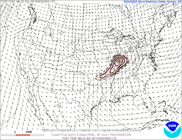
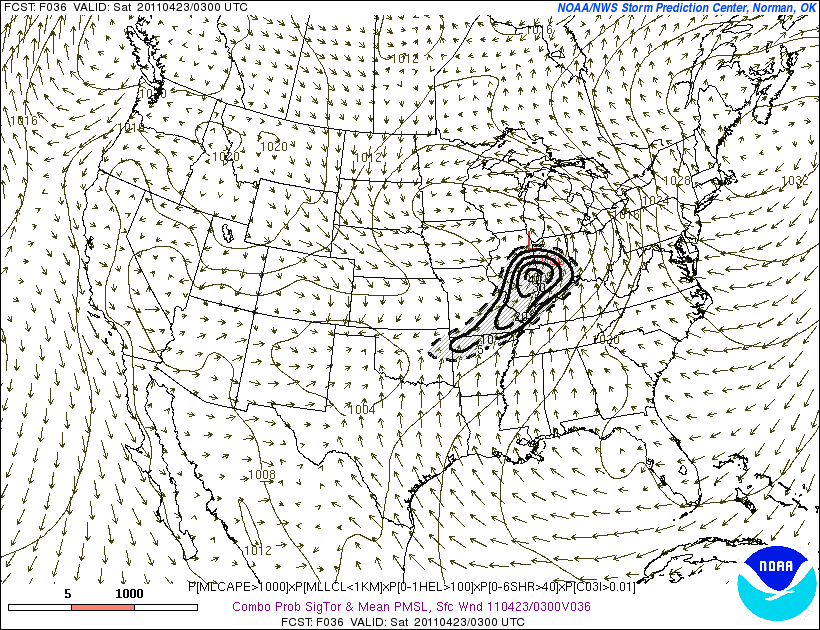
Here are a couple of tornado potential maps from the NAM and SREF valid Sunday evening:

Notice the values are highest in Illinois, suggesting that is where the greatest tornado potential resides. By the time the storms reach us, the most favorable shear for tornadoes will have departed. However, wind fields aloft will still be quite strong. Thus, I expect our main severe threat to be damaging winds with hail a possibility in any stronger cells. An isolated tornado or two cannot be ruled out, especially in the northwest portion of the state.
Recalling The Nation's Biggest Tornado Outbreak On Record...The 1974 Super Outbreak
April 3, 1974 is a date that those in the weather community will always remember. It was an unseasonably warm day as a strong low pressure moved through the Corn Belt. This unseasonably warm air and a combination of several other factors would come together just right to produce a spectacular severe weather event, leaving hundreds dead, thousands wounded and an incredible amount of destruction across a number of states.
The first tornado in the state touched down in Boone county in the early morning. 21 of the 148 tornadoes occurred here, including 1 F5 and the devastating Monticello tornado. The thunderstorm cell which produced the Monticello tornado produced its first Indiana touchdown near the Illinois state line in rural Warren county. This tornado died out but was followed by another touchdown in Warren county. That tornado tracked northeastward into southeastern Benton county before dissipating near Otterbein. Another tornado followed almost immediately, moving quickly northeast through the northwestern part of Tippecanoe county and into White county. As the tornado passed northwest of Lafayette, the 2200z METAR from KLAF included a report of a tornado:
METAR KLAF 032200Z 16025G33KT 7SM TS SCT040 BKN070 OVC150 23/17 A2914 RMK TB44 W MOVG E LTGIC W-N PRESFRLAF3/16 STATE POLICE RPT AT 2151 5TORNADO SLP864 T02280172
The tornado continued through mostly rural areas of White county before taking aim on downtown Monticello. Heavy damage occurred in Monticello with several fatalities. But it was not done...
The tornado continued northeastward through Cass county and Fulton county, where it produced significant damage in Rochester. It proceeded through Kosciusko, Noble and LaGrange counties before finally ending its incredible 109 mile reign of terror near Oliver Lake. The same thunderstorm produced another weaker tornado near Plato, which would be the final tornado in Indiana from this particular thunderstorm.
In all, 47 Hoosiers died that tragic day with hundreds more injured.
 |
| Approximate Tornado Tracks |
Saturday, April 2, 2011
Severe Weather Still Likely On Monday, But Magnitude May Be Tempered
The latest models have trended more toward the recent runs of the ECMWF in terms of the system evolution and timing. It now appears that the cold front will move through earlier on Monday. The potential for a high end severe weather event looks to be lessening but I still see a severe weather threat across much of the state with damaging winds, large hail and isolated tornadoes possible. Assuming there are no major changes in the next day or two, I would not be surprised to see the SPC issue a Moderate Risk in or near the state.
Friday, April 1, 2011
Severe Weather Likely On Monday...And It Could Be Significant
While there are still some differences amongst the models, they are coming into better agreement on the evolution of the next trough. Chances for thunderstorms will begin to increase on Sunday, especially across the northern half or so of the state. Some of these could be severe with the main threat being hail, but the bigger severe weather threat looks to hold off until Monday.
The precise evolution of the system will be critical in determining the magnitude of the threat. Regardless, model instability forecasts continue to look impressive by early April standards with good low-level moisture under an EML plume/steep lapse rates aloft. It's still too early to get very specific but a multi-modal severe weather event is looking increasingly likely for a good chunk of the state, with hail, damaging winds and tornadoes all possible.
More on this in the coming days...
Subscribe to:
Posts (Atom)